CASC-Developed Satellites Contribute to Flood Control
Five satellites including the Gaofen-1, 3 and 6 have been continuously observing regions at high-risk for flooding in South China for the past month.
The observation mission is carried out by the China Centre for Resources Satellite Data and Application (CRESDA), a subsidiary of China Aerospace Science and Technology Corporation (CASC).
The Gaofen satellites had already played a role in typhoon, earthquake and forest fire rescues and are irreplaceable in monitoring this year's floods.
The Gaofen-3 satellite in particular has played an important role in the observation by collecting 118 pieces of important data.
The satellite, which started operation in January 2017, was China's first C-band multi-polar synthetic aperture radar (SAR) imaging satellite with 1-meter resolution.
Different from other optical remote sensing satellites, Gaofen-3 can disregard weather conditions and work 24/7. Its microwave signal goes through cloud and fog, reaches the ground and is then reflected back to the satellite.
By July 13, the satellites had made 248 effective data returns.
According to Chen Weirong, director of the user service office of CRESDA's remote sensing operation division, satellites responsible for the observation carry out at least two emergency recordings per day. The data is then processed and transferred to the Ministry of Emergency Management, the Ministry of Natural Resources, the Ministry of Water Resources and the China Meteorological Administration as well as local governments of the disaster-affected regions.
So far, observation has mainly been focused on seriously-hit areas such as East China's Jiangxi and Anhui provinces as well as Central China's Hubei and Hunan provinces, with particular attention to areas like Poyang Lake, Taihu Lake area and Huangshan of Anhui.
Data from the satellites is mainly stored on a land observation satellite data service platform on which real-time ground observation service with high definition and large size as well as historic remote sensing data from the last 20 years can be found.
In other words, the platform is a technical support, from both time and space dimensions, for flood rescue as well as a disaster prediction and assessment resource.
Chen added that the emergency monitoring remote sensing data of this year's natural disaster is open to the public. Institutes and organizations can apply for the data and download it after registration.
In addition to CRESDA, other subsidiaries of CASC also used their advantages to contribute space support to the flood control.
For example, Sino Satellite Communications Co., Ltd helped Dulongjiang town in Southwest China's Yunnan province build broadband satellite communication links and provided reliable and safe broadband emergency service when mudslides and landslides occurred.
The Fengyun meteorological satellites developed by the Shanghai Academy of Spaceflight Technology are providing service for the China Meteorological Administration and the National Satellite Meteorological Center (NSMC). Data collected by the satellites have been used in weather broadcasting and climate monitoring.
Water of some main lakes and reservoirs like Dongting Lake and Miyun Reservoir were monitored by NSMC relying on the Fengyun satellites during the first half of 2020. So far, 25 hydrological monitoring reports have been released.

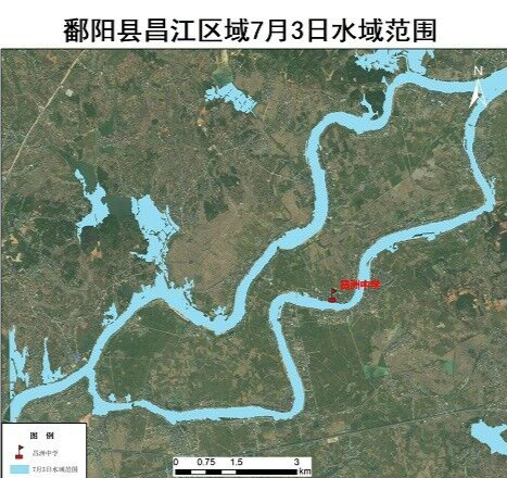
Image of the Changjiang River in Poyang county of Jiangxi on July 3 [Photo/sasac.gov.cn]

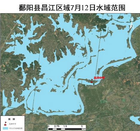
Image of the Changjiang River in Poyang county of Jiangxi on July 12 [Photo/sasac.gov.cn]
(Executive editor: Wang Ruoting)


