CASIC in Full Swing in Building Innovation-Based Radar Industry
China Aerospace Science and Industry Corporation (CASIC) is now working on industrial innovative projects to offer high-quality technological service and turn technological value into economic value.
The radar industry is one of its first demonstration projects.
A professional radar research center of CASIC is promoting developments related to weather radar, surveying and mapping and new material industries in several regions to strengthen its innovation-driven capacity and speed up application of its technological achievements.
So far, a primary pattern of coordinated development of industries around the nation has been formed.
Weather radar helps daily life
Meteorology is close to livelihoods. The temperature, the weather… they sound like trivial things in daily life but people always ask about them.
The research center established the first large-scale meteorological company in China's space industry.
Based on CASIC's work with Jiangsu Radio Scientific Institute Co., Ltd a meteorological equipment production line was completed that focuses on development of multiple space-air-ground-ocean platform observation products to meet the meteorological need of super-large cities.
The platform will also provide meteorological supporting services including detection of civil aviation's low level wind shear and trailing vortex and early warnings of advection fog and emergency meteorological for large-scale activities.
Data service capacities of meteorological products used in different environments are also being improved and will support automation and service of agricultural meteorological observation.
For example, the company has developed an agricultural meteorological observation system on the basis of an automatic weather station to help white tea growers monitor the growth status and environment of their tea trees.
The system can also be used in farming of other crops including rice, corn, wheat and cotton.
Surveying and mapping boosts regional development
Geographical mapping is one of the significant factors in precise poverty alleviation and local agricultural development.
Optical equipment is currently widely used in geographical mapping in China but is limited in Southwest China's Yunnan, Guizhou and Sichuan provinces where there are more clouds and fog.
In such areas, the measurement is easily impacted by a lack of light or by cloud and fog.
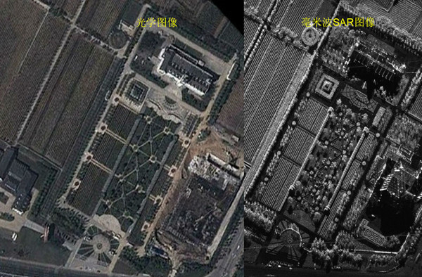
To overcome the disadvantage, the company applied its air-borne millimeter wave (MMW) interferometric synthetic aperture radar (InSAR) in mapping of the areas, which provided data needed for economic development and construction.
In early May this year, the company obtained key mapping basic data of several flight demonstration areas at the large scale of 1:5000 in Guizhou. The data will contribute to regional road planning, economic development, farming and monitoring of conversion of cropland to forest.
The interferometric synthetic aperture radar is a kind of high definition imaging radar which can recognize targets automatically and works 24/7, which means whatever the weather is like and whether it is in the day or night, measurement can be obtained.
It also features unique on-machine processing that other conventional radars do not have. It is a more effective mapping device suitable for areas in Southwest China.
The company also improved the performances of the device and lowered its costs to promote its application in more industries.
As real-time data collection and updating plays a more and more important role in such aspects as national land resources, environment, urban planning, emergency affairs, economic planning, housing, traffic, railways, statistics, public security, agriculture, forestry and maritime social and economic development, better performances of the measurement devices are increasingly in demand.
In February 2018, the company completed China's first imaging radar mapping project with the air-borne MMW InSAR system and in the next two years the system was tested several times in Yunnan, Guizhou and Sichuan.
According to the company, demonstration flight missions will be continued in Yunnan and Sichuan in the second half of 2020 to collect mapping data of different terrains and landforms and develop more potential applications.

Images made by optical devices (L) and the MMW SAR system (R) [Photo/sasac.gov.cn]
(Executive editor: Wang Ruoting)


